How to make a navigator from a Supra tablet. Pros and cons of our idea
06.04.2017
In the age of progress and information technologies getting lost in a foreign city is quite difficult if you have a navigator. But what to do when there is no navigator in your car? Just make it from a tablet. We will tell you how to implement everything, as well as the models and software suitable for this, in this article. Process of preparation and implementation A person needs a navigator for orientation on the ground. Moreover, it doesn’t matter whether you drive a car or walk. The navigator will guide you in any case. But first of all, you and I need to find out whether your tablet has a navigation program. To get started, go to your applications. There is a "settings" button there. If you find a "location" icon there, that's very good. Open and look for the “GPS satellites” button. Click on this button and see that you have navigation. Next we will need applications with area maps, such as Google maps or Yandex maps. About Google Maps After you have accessed Google Maps from your tablet, indicate your location there. If possible, connect Wi-Fi for ease of operation of the application and downloading maps. Google is very convenient to work with maps. You can lay out the entire route from point "A" to point "B". There is also the opportunity to set intermediate points and the desired travel time. It's easy to control the application directly from your tablet. You can look at a satellite version of the map, a diagram or a hybrid. If there is no navigator program If a navigation program for your tablet is not provided initially, then this is not a reason to be upset. Just download the desired program from the Internet or directly from Play Market. What applications, besides Yandex and Google maps, can you download? So, here are some of them: Sygic GPS Navigator. A convenient application for car enthusiasts Maverick GPS Navigation. Ideal for pedestrians, but car enthusiasts can also try it. It has a clear and simple interface Navitel Navigator. Classic navigation. The application was developed for Europe and the CIS countries. Here are some navigation programs. Next, we’ll look at which tablets with GPS functionality are suitable for these programs. Tablets with GPS Of course, now it is rare that a tablet does not have this function. But can it compete with a full-fledged navigator in terms of terrain orientation and ease of use? We can safely say that it can. Let's see what kind of tablets there are. Samsung Galaxy TAB 2 10.1 GT-P5100 Titanium Silver. Very reliable tablet. FreeLander PD20 is capable of high-quality work at a speed of 500 m/s and at an altitude of up to 18 km. A budget option. But despite this, it works well in the Treelogic Gravis 72G 8Gb navigation program. Conducts GPS signal well. Equipped with a built-in Navitel Superpad Flytouch 4 3G navigator. This model is distinguished by high processor power and voluminous RAM. ASUS memory Transformer Pad TF300T 32Gb blue dock. Supports A-GPS connection. It has digital compass. This tablet already has a program installed Google Maps, but if you wish, you can download any other Digma iDn7 3G. Built-in warning function about traffic jams and congestion within the mapped route Pros and cons of a tablet navigator Pros Wide screen. Larger than the display of a conventional navigator. Network access. You can, for example, look at traffic jams on a route. Powerful processor. It is possible to load heavy maps faster Computer functions. You can watch a movie or play. For example, in a traffic jam More powerful battery. Consequently, longer work without recharging. Large selection of navigation programs. Various alternatives to suit your personal taste, and there is no restriction of using only one program Cons There is no special mount in the car for the tablet. Therefore, you will have to look for it, or use it like this Absence stable signal GPS in budget models tablet. High price on good models with perfect satellite signal It's possible that big screen for some it will not be a plus, but a minus, since it may block the view. From all of the above it follows that the tablet is a good replacement for a classic navigator. The only criterion for a replacement to be truly worthy is the price.
The auto portal website also has groups: Classmates, And In contact with. Join us!
Did you like the news? Tell your friends! Found an error or typo?Select it and press Ctrl + Enter
Subscribe to our channel in Yandex.Zen
-
Specialist. reporting site
The Russian premiere of the new Mitsubishi L200 took place
- 26.02.2019
-
Specialist. reporting site
Winter is in full swing, the tires are on fire. Viatti Bosco Nordico test.
- 17.02.2019
Experts spoke about cases where a driver may not be issued a license after completing training. Experts noted that in recent years the number of accidents has increased, and the rules for gaining the opportunity to drive have become more stringent.

Many people believe that in modern world A car is no longer a luxury, but rather a necessary means of transportation. It is known that in order to obtain a license, the driver must undergo training in accordance with the rules of the traffic police, as well as a medical examination. Many people do not know, but there are cases when they may be denied rights.
In order to obtain a driving license in the Russian Federation, a driver must be 18 years of age; they cannot be issued early. Disabled citizens with certain physical disabilities, such as epilepsy or mental retardation, can drive vehicles only if they have special devices for this.
Acquired diseases can also become an obstacle to obtaining a driver's license. For example, if during a medical examination it turns out that a person’s vision or hearing has deteriorated, he may be denied a document.
Age may be an obstacle in this regard. The driver may simply be unfit to drive due to physical limitations that deteriorate over the years.
It is worth considering that only a medical board can refuse to obtain a license, because many citizens hide the fact of alcohol or drug addiction, which is difficult to find out even during an examination. Experts advise obtaining documents through legal means, since otherwise it is criminally punishable.
A recent monitoring of prices in the Russian car market by experts from the Internet portal "Price Auto" showed that the crossovers of the Chinese Chery Tiggo 3 line decreased in price by 7% (about 62,000 rubles). At the current price for such a car 2018. in the Comfort MT modification you need to pay 777,900 rubles.

The prices for the Luxury Plus MT modification (RUB 899,900) and the Luxury Plus CVT modification (RUB 999,900) remained the same.

It is worth noting that the power unit of all modifications of the model under discussion is a 1.6-liter engine with 126 hp.
As previously reported, the automaker has already edited prices for the model under discussion this year. True, then, in February, prices went up by 20,000-30,000 rubles.
According to the results of the first quarter of this year, Russians became owners of 1,229 cars of the Chery line. This is 5% lower than last year.
However, falling prices now indicate that Chinese businessmen are taking a flexible approach to trends in the automobile market. It is very likely that the price reduction will increase demand for Chery Tiggo 3.
Russian President Vladimir Putin signed Federal Law 607168-7 Federal Law, under which car owners whose cars are reported stolen are exempt from paying transport tax.

Previously, car owners of stolen cars were also exempt from paying transport tax. But then the system for obtaining such exemption was, to put it mildly, “intricate.”

Those. you will be exempt from tax, but only for the period while the car is officially wanted. And then (search activities have their own time frames), either go and deregister the car, or pay tax.
Now this injustice has been corrected. And no tax is charged from the moment of loss until the month in which the car was returned to the owner.
As for such a parameter as the entry into force of this law, it is already in effect. After all, it was reviewed on April 10, and the president signed it on April 15. On the day it was signed by the President of the Russian Federation, the law was published.
IN this document was marked “valid from the moment of acceptance.”
At the eBay auction, a unique Alfa Romeo roadster from the car fleet of the legendary boxer Muhammad Ali was put up for sale as a lot.

Spider Veloce Series II was released in 1976, and its mileage was about 130 thousand kilometers.

On this moment The price of the lot at auction is $13,500. The Alfa Romeo Spider is sold in good condition, it has been repainted, but the craftsmen have retained the original soft roof and alloy wheels.

The roadster's equipment remains: the original steering wheel, radio and black leather interior. According to the seller, the car had two owners: athlete Muhammad Ali and his friend Tim Shanahan. The latter has owned the model for the last 40 years.
Under the hood of the roadster there is a two-liter naturally aspirated engine with a capacity of 133 horsepower. It is paired with a five-speed manual transmission.
The car has rear-wheel drive and disc brakes.
The main feature of the roadster was improved interior trim and designer door handles. In 1974, the model was released in the new Spider-Targa modification, equipped with a Porsche-style rear window and roof panels made of fiberglass.
The Germans, in this case, must thoroughly modernize the car that participated in the climb to Pikes Peak. Version ID. The R received a new rear wing with a modified design. DRS racing technology reduces aerodynamic drag. Specialists optimize the car's energy management system. Version ID. R was introduced in 2018 at a special event in France. The vehicle is equipped with two electric motors generating a total of 680 horsepower. The car weighs 1.1 tons. The racing version of the electric car is capable of accelerating to the first hundred in 2.25 seconds.

Volkswagen ID pilot. R in the race at the Nürburgring will be the French driver, Romain Dumas. Track record among modern electric Vehicle currently belongs to the Chinese model NIO EP9. The car covered the circle in 6 minutes 45.9 seconds. Wherein average speed was 185 km/h.
 The latest version is probably best GPS navigator on Android - Navitel Navigator. From Russian developers. It can do everything that a mobile navigator should be able to do: 1. Voice prompts (voice can be selected) 2. Support for time-varying POI with search (POI - points of interest, such as cafes, cinemas, attractions) 3. Built-in services Navitel.Traffic and Navitel. Events (the names make it clear why they are needed, they are not available in all countries) 4. SpeedCam displays (locations of traffic police cameras/radars) 5. 3D objects 6. Automatic map updates directly from the application
According to the developers, they listened to user recommendations and improved their creation. There are fewer bugs (but they are there), now it will work even on the most powerful tablets, perhaps even on Chinese devices. Write in the comments how the program works for you.
![]()
Maps for Navitel
Maps for Navitel Navigator of some CIS countries, throw in NavitelContent/Maps (attention, this is new format cards, for the 7th version of the application, if you have Navitel version 5, they will not work): Russia Belarus Ukraine Kazakhstan
How to install Navitel Navigator on a tablet
At first everything is standard, click on the link below. Installation is complete and acceptable. Next, download the maps from the links above. , or just any file manager find the NavitelContent folder. This folder will be both on the memory card and in the device’s memory, choose where it is more convenient for you to store cards, where there is space. Go to this folder and find the Maps folder. This is where you copy the downloaded maps. Once copied, launch/restart Navitel Navigator. Everything should be picked up.
Detailed review mobile application"Navitel Navigator for Android": setting up GPS on your phone, adding maps, setting up the navigator to work without the Internet
If you intend to travel while driving a car, or need to go to another city for work, or just get out of town into nature, you don’t have to constantly look at maps or buy a navigator to navigate the road. Of course, Navitel can be used as a car navigator.
Simple and convenient application « Navitel for Android» from the leading manufacturer of GPS navigators for Android and digital maps can be downloaded for free to your Android mobile gadget, replacing a regular, stationary GPS navigator with a simple apk application. Among other things, Navitel supports the Russian satellite system Glonass, so it can be used in places where access to other satellites is difficult.
In general, Navitel will allow you to much faster find the right path in unfamiliar places using local maps, which can be downloaded for free to your smartphone or tablet via the official website, torrents or the 4pda.ru portal.
First launch of the Navitel application on Android
First of all, the user should download the Navitel program for free GPS navigator& Maps" with official store Google Play to the phone. Next, you will be asked to select the type of voice navigator and maps of the countries you are interested in. It is worth noting that their weight is quite impressive: if the description of the route of Ukraine weighs less than 500 MB, then the “Navitel” map of Russia will take up almost 1.5 GB on your tablet or Android phone. As soon as the specified map is downloaded, you will be able to log in to the system by first registering or using your existing social accounts Facebook networks, VKontakte or Google+. After which the program interface will open in front of you. The navigator works great without the Internet, for this reason it will be the best choice for many Android users.
How to download navigator for Android for free on your tablet/smartphone
Go to the website navitel.ru, section " Download". Here is a list of free Navitel Navigator distributions for various platforms and devices. On the download page there are different versions Navitel Navigator programs: universal version, WXGA, WVGA800, QVGA, VGA, etc. In short, it depends on the size of your screen mobile tablet or smartphone. Maps and full version distribution kit "Navitel Navigator" is also available for downloading on torrents and mobile portal 4pda, however, in these cases you are dealing with unlicensed software, which everyone is free to use at their own peril and risk.
Please note that the free version of the navigator works for 7 days in demo mode, after which you must activate the key for Navitel, otherwise the program will work in limited mode.
How to install Navitel on Android?
To install, you need to download the apk distribution kit downloaded from this page to a memory card or to internal memory phone, and then run the installer. In principle, installing Navitel on Android is no different from any other mobile application (not necessarily a navigator). During installation, you need to familiarize yourself with the access rights of the Navitel application, confirm and wait for the process to complete. After this, you can launch the navigator through the icon on your home page Android screen or through the "Applications" menu. Pre-setting GPS is not required for Android, the main thing is that the GPS module itself is present in the phone.
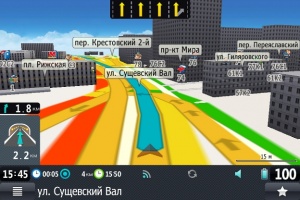
Navitel map screen
Most of the screen of the NAVITEL navigator is occupied by an interactive map, interaction with which is carried out by moving your fingers across the screen. That is, to move the map, you should hold the screen with your finger and move it in the desired direction; to change the scale, you should “push” or “move” the map with two fingers; also, the “+” and “-” buttons are displayed on the right side of the screen to increase and decrease the scale, respectively. .
In addition to scale and position, the user can switch the view between a three-dimensional and two-dimensional map, which is very convenient in certain situations when working with a navigator program. On the left side of the map screen there is an indicator of the speed at which the user is moving, in “km/h”. To determine your location and calculate the specified speed, enable the ability to receive geodata via GPS on your Android device.
Top panel of the Navitel program for Android
At the top of the screen of the Navitel Navigator GPS & Maps application for tablets and phones on Android OS there is a black panel with several useful functions, quick access to which will save you from unnecessary movements, especially if you are in a car.
The compass icon opens three options for the Navitel on Android navigator: switching between a two- and three-dimensional map, turning on/off the night skin and rotating according to movement. The night view of the application is designed in a less bright style, so turning it on will reduce eye strain and also allow the driver not to be distracted by the glowing screen. Rotation according to traffic can be useful in some areas of the city. An alternative to this feature is North Up, which returns the map to its natural position depending on the orientation of the mobile device.
Appearance of the Navitel navigator for Android OS
The next navigator icon is designed to work with sound in the Navitel Navigator application. With its help, you can turn off any sounds, and also select a mode whose parameters will be used during playback sound signals applications.
The letter logo is intended to lead to the “chat” service, in which you can correspond with other owners of the Navitel program. However, the usefulness of such a function remains in question. The next button allows you to track the position of friends and other registered users.
The satellite icon in the top bar of the application screen provides access to GPS settings. In addition to enabling/disabling the service itself, you can also track the quality of the connection, determine your coordinates, and even the number of flying satellites interacting with the device. Near the satellite sign there is a button with a cloud, with which the user can open a window for communication with the “cloud” - an Internet server on which you can save all the routes you have recorded and control points. This feature allows you to save the specified information in case of problems with your Android mobile device when interacting with satellites.
A green traffic light opens the traffic map settings menu in the Navitel application. Here you can update satellite data, as well as adjust some features. Traffic jams themselves are displayed on the map as a change in the color of the road: red – traffic jam, orange – difficult, yellow – heavy traffic, and green – clear path.
Navitel for Android program: looking for the shortest route on the map
To the right of the traffic jam menu button there is an indicator of the battery charge of your Android (tablet/phone), and the last icon on the panel on the right - the sun - allows you to find out the current weather, which is important for pedestrian and car navigation. In this window you can view temperature, pressure, wind speed and the nearest weather forecast.
Creating routes in the Navitel program for Android
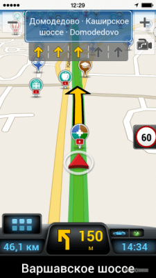
To create a route in “Navitel Navigator GPS & Maps”, go to the program settings menu (green button at the bottom left of the screen), then “Route” - “Create route”. You will see a list of types of possible routes: by address, nearby, by a friend’s position, by existing waypoints, by points from the route history, by “favorite” most visited points, by coordinates or independently on the map. Select the end point one way or another, then click “Let's go!” After completing the actions, the application screen will display Additional Information about the distance to the point, the distance to the nearest turn, the remaining time and the approximate time of arrival at the specified point.
To create a route using several points in Navitel, just select the third point on the map, then open its properties in the program and select “Enter” or “Finish”, depending on your route.
We create a route on an Android device using a GPS application
By clicking on the arrow in the upper left corner of the screen, you will open an additional route settings menu, where you can turn off this route, adjust the detour by changing the given trajectory, simulate the route, or go to the navigation settings on Android.
Description of navigator settings (for Android OS)
The following subsections are available in the Navitel settings:
- Map. Here you can set the map scale limit, switch modes between 2D and 3D, and also specify other parameters related to its display.
- Other cards – the button is used to select other cards you have.
- Navigation. In this section you can select the type of transport, from car/motorcycle to pedestrian.
- Program interface - allows you to configure functional buttons on the map, a timer for displaying the top panel and buttons.
- POI filtering – a menu in which you can select objects that should be displayed on the map. The Navitel Navigator GPS & Maps program shows objects in different areas: car maintenance, places to eat, shopping centers and shops, places of entertainment, transport communication points, banks and ATMs, as well as many others.
- Online services. IN this menu you can adjust all the settings of the Android application related to Internet communications. Among them: selecting the type of connection, updating the weather and displaying traffic jams, as well as other services.
- Warnings Using this section you can set various sound warnings and alerts. For example, a signal when a specified speed is exceeded or when the user’s car is approaching a dangerous intersection.
- Regional settings. Here you can select the language of the interface and maps for Android, as well as the voice of your navigator.
- System. The menu that contains most of the functions from the top bar of the main screen, as well as the path where the map files are located.
- Sensors In the specified section of the application there are various sensors and metrics such as top speed or distance traveled.
In other sections of the menu, you can create your own settings profile, as well as save tracks - routes for Android.
Navitel Navigator in action
How to update Navitel Navigator
The latest version of Navitel can always be downloaded via Google Play market. Make sure that your phone is connected to the Internet, open the application and select My Navitel > Updates > Navitel Navigator in the main menu. Next, click the Update button to download latest version navigator on an Android device.
The second way to update the navigator is to download the file directly from the official website navitel.ru/ru/downloads. Select the appropriate version of the application, optimal for the Android version and screen resolution. It may happen that you download the distribution in zip format. This file must be manually renamed with apk permission.
Summary. Despite the fact that the Navitel Navigator program itself for the Android device is free, in order to download any map you will have to pay. For example, a map of Russia will cost users about 27 dollars or 1800 rubles, which is quite a lot. However, having paid once, you will be able to use the impressive functionality of the application for a long time on a virtually free basis, downloading the latest Navitel updates and additions to your phone or tablet.
Main advantages:
- Navitel can be used as a car navigator for Android,
- supports Glonass,
- works without internet,
- the cost of cards is relatively low
- good detail maps
Navitel Navigator: questions and answers
Will the navigator for Android work without the Internet?
Answer. Yes, an Internet connection is only required to download and update Navitel. Directly during operation, the navigator requires a connection to satellites and the presence of downloaded maps on the mobile device. If they are not there, then the navigator will not work correctly both in the local environment and when connected to the Internet.
Does it make sense to download free Navitel from pirated sites?
Answer. Definitely not. Firstly, no one forbids you to use official version GPS navigator in demo mode. True, this period lasts 7 days, but during this time you will be able to fully familiarize yourself with all its functions. The pirated version does not allow you to download and update maps of cities and countries. Since the license for Navitel Navigator does not cost that much big money, we recommend using this option. This guarantees technical support, as well as regular and free updates kart.
In the life of every motorist, it happens that you find yourself in unfamiliar places. Often in such situations the question arises: is my car moving in the right direction? This issue can be easily resolved. Nowadays, almost every family has a tablet computer, but, unfortunately, not many know how to make a navigator out of a tablet. But with its help you can easily find the right direction to the object you are interested in, the nearest cafes, gas stations, service stations.
The easiest option is to buy a tablet with a navigator. You just need to learn how to use the device. Let's look at another option. Let's say the tablet is already in stock. How can I find out whether it can be used as a navigator or not? It won't be difficult.
Checking the connection
- Turn on the tablet device;
- go to applications;
- download the maps of interest to your device from the playmarket;
- in the settings we find the “Location” option;
- We select the location data that is suitable for us and see if there is an item - GPS satellites.
This seems to have been sorted out, but how to use the tablet with the navigator function further? If you are in mobile internet, it is better to switch to Wi-Fi, you will need to download a lot of different things, and through the latter it is several times faster and cheaper. We took the device based on Android based, so it's better to use Google app Maps or as it is also called Google map. It is located in the main menu of your device. We establish our location during the first turn on. We find an icon on the screen in the form of an arrow pointing upward, which shows the direction of our movement. It is he who will guide our route throughout the entire journey.
Here you can find a route to an object by indicating your location and the point of the object itself. The application will draw your route on the map and show the average time you will spend on the road. There is even an option that when you enter travel time into the database, a route will be selected for you that will take exactly the amount of time you planned.

But what to do if you want to use a tablet navigator without an Internet connection, and besides, the device does not support GPS? In this case, we recommend using an external GPS receiver. There are two connection methods, which one to use depends on technical characteristics your device.
Important! Some are not compatible with specific models tablets.
Therefore, before purchasing a receiver, make sure it matches your tablet computer.
In the video you can clearly see how the tablet works as a navigator:
First connection method. Via Bluetooth
Turn on the tablet and module. On the first one, we connect Bluetooth and wait until they start interacting.

Next, set a password to connect devices to each other (usually the password is three zeros). In the tablet settings we allow using GPS to determine location. Thus, we have a full-fledged navigator or tablet with GPS.
If the navigator does not connect to the module, you will need to download the Bluetooth GPS Provider program from the Play Market. You will have to run it before each time you turn on the navigator on your tablet.
The second connection method is via USB
The first option is a little simpler than this one. First, download and launch the USB GPS 4 Droid program. During its operation, mark Start-Stop GPS with a quotation mark. With these actions we activate the Choose GPS device speed item, where you need to enter the code that is indicated on the receiver. Next, in the tablet settings, go to the “For Developers” application, and mark the “Fictitious location” column in it. Everything is ready, launch the navigator and check its operation.
Variety of navigation options software for android pleases the eye, but at the same time frightens an inexperienced person with its quantity. You have a choice - use the free version or buy the program in a specialized store, download and install the navigator on your tablet for free.
Necessary properties for a tablet navigator
There is no point in using devices with a diameter of less than 5 inches for these purposes. A tablet of 10 inches or more is a completely different matter. Everything will be perfectly visible on it, but a very large one will reduce the visibility for the driver. Therefore, the most optimal device for using a tablet as a navigator in a car would be a device with a screen size of 7-8 inches.
Which operating system A tablet for a navigator is preferable, naturally - android. The advantage over others is ease of operation and installation, transparency of settings and large quantity various devices. When purchasing a new device, it is best to purchase a tablet with GPS and 3G support. Although all tablets currently offered have fairly strong components that can cope with almost any task. But still, the presence of GPS guarantees that there will be no need to purchase an additional module, and 3G will allow you to use the device to a greater extent and allow you to deal with traffic jams while the car is moving.
Not all manufacturers include the device with a holder. Therefore, you should think in advance about how you will use the navigator on your tablet while the car is moving.
If the tablet navigator program is not installed on your device, you will have to choose one of many navigation applications. Domestic manufacturers and application developers offer a variety of high-quality products to choose from, located on high level. Let's look at a few of the most common ones.
Navitel Navigator
The application actively leads in the number of users of smartphones, tablets and navigators. It accounts for about 60% of all sales and downloads. It differs in that it is multi-platform and supports large quantity different languages. Navitel Navigator also has an extended technical support.


This application is one of the most popular Yandex developments. All maps in this application are updated and downloaded to the device gradually, as needed. Its advantage is the ability to view photographs of monuments, landmarks and buildings that other users post online. Another plus is that the application has a voice prompt module.

The fact that this domestic development belongs to highly functional applications is evidenced by the fact that the Togliatti Automobile Plant installs it on the built-in navigators of its cars, and the commercial licensed version of the application is used by many transport companies. The main advantage is the presence of “Traffic 2.0” technology. It displays the situation much faster than its competitors (Navitel or ProGorod).
Operating this application is simple and does not require any additional skills. The advantage is the presence of a system of dynamic corrections that reflect real situations occurring on the road.

One of the widely used navigators that do not require the Internet. The destination is indicated by a red flag; you can set it with a dot on the map or by entering a specific address in the search bar. The downside is that the free version of the application allows you to download only 10 maps.
Free version works without interruption and guides the user through 2D maps. All downloaded maps are updated at least once a month. The downside is the lack of voice prompts and limited access to 3D maps. These options are only available in paid version applications.
Benefits of using 3G GPS in a car
- Calculate average fuel consumption and calculate the cost of the distance traveled.
- Checks the accuracy of the car's speedometer.
- Will help you find a hotel, cafe or store with an ATM.
- With it, you will be able to view the weather forecast or news via the Internet.
- Check your email or page on in social networks.
- Play a game or watch a movie at the stop.
- Capacity battery tablet computer higher than on navigators.
But most of the above is available by installing the appropriate programs and applications (software) on the device.
Disadvantages of using a tablet as a navigator in a car
To a greater extent, for tablets there is no panel mount, so you will have to figure it out yourself. The GPS module is powerful only on expensive models; the use of cheaper devices risks that the signal may periodically disappear (for large cities this may occur when driving through tunnels, bridges and overpasses).
Currently, Chinese manufacturers offer their customers a tablet with a TV tuner and a navigator, as well as a tablet navigator and a DVR. These devices, as a rule, belong to little-known manufacturers, but they differ from branded ones in their wide functionality. Their prices are naturally lower than those of well-known brands.
Attention! In the event of a breakdown or any malfunction, the user will have to decide whether to repair or return Money by mailing the device at your own expense to the Middle Kingdom.
When purchasing a branded device, just contact service center repairing phones, laptops, navigators, tablets and other equipment.
It is physically impossible to know every street. Well, what to do if you find yourself in a huge foreign city? Get lost? No. Not in our age and not with our technologies. Now almost everyone has such a thing as a tablet. And today we are talking about how to make a navigator out of a tablet.
Preparation and miraculous transformation
The very concept of “navigator” implies: an assistant in terrain orientation. And our faithful friend the tablet will solve this issue for us if we help him a little. Whether we walk or walk, the tablet doesn’t really care. This is a question for the software being installed. But more about it below.
Now let’s figure out whether our tablet can act as a navigator. So where to start? If until now we didn’t have the information on our tablet, then it’s time to master it.
Step by step to a miracle
Go to “Settings”, which is in the “Applications” menu, and look at the “Location” button there. She is - hurray! We are on the right track. Next, we look for “ GPS satellites" Found it? Look how it's flooded. The “companions” immediately celebrated. And we realized that we have a navigator for the tablet.
To further advance along the chosen path, we will be provided with maps of the area. There are a lot of them. The most convenient and therefore popular are Google maps and Yandex maps. And since the base of our device is called Android, we are happy to use the first one, i.e. Google.
Video on how to enable GPS on Android:
Oh almighty Google Maps
We access the application from the main menu of the tablet. The first time the program meets us, it will ask you to indicate our location. Which is what we do. I advise you to switch to a Wi-Fi connection at this stage, if you haven’t already, because you will have to download a lot.

Car owners will appreciate this application. Here you can immediately specify two points (start and end) and plot the desired route. We can even set the travel time that we would like to spend on this trip. We can access Google Navigator using the icon with an up arrow. After all the operations performed, we can view in detail the entire laid path, and there is also a menu that controls the tablet.
If the manufacturer does not provide cards
Here's the problem: when we carried out the first steps in searching for a navigator program on a tablet, which are described at the beginning of the article, we discovered that it was missing. It's no big deal. We don’t worry, but install maps from the Play Market ourselves (when we have Android, if not, there are maps for any platform). And then everything follows the previously stated scenario.
Here I want to pay tribute to Yandex maps. Even if the manufacturer deprived us of a navigator in the configuration of the device, this application determines the location using Wi-Fi connections and works with A-GPS.

And in fairness, I’ll mention a few more good applications that you can install and not regret about it:

These are the applications that allow you to use your tablet as a navigator. Next, let's look at what there are that allow us to do this. After all, in order for everything to work out, our tablet must have a built-in GPS module.
Models with GPS, all the pros and cons
Today, you probably won’t find a tablet that doesn’t have a built-in GPS module. But we are concerned about something else: will such a device work as well as a GPS navigator specifically designed for terrain navigation? Will. And in some aspects, a tablet is even better than a dedicated GPS device.
Brief overview of tablets
Now we know how to use a tablet as a navigator, and below are some models of tablet devices in different price categories and with different capabilities:

Pros and cons of our idea
Modern tablets have all the qualities of GPS navigators that allow them to be used in a car. Well, in what ways they are superior and in what ways they are inferior, let’s look further.


Here are the pros and cons. The conclusion from all of the above is the following: a tablet is a worthy replacement for a navigator. But if we want to replace the navigator with a tablet, then the latter should be medium or High Quality . Then this replacement will be complete and will not cause us any complaints. But Chinese ones are not suitable for these purposes due to their low navigation parameters, and the hardware itself in general.
Please add comments to the article below and express your opinion on the topic.